NSW Department of Primary Industries and Regional Development
FishSmart
Overview
NSW FishSmart is New South Wales Government’s authoritative digital platform for recreational fishing regulations and compliance information, operated by the Department of Primary Industries and Regional Development.
The platform delivers accurate, location specific fishing rules, bag limits, size restrictions, and legislated fishing zone boundaries to over 350,000 users across New South Wales waters, including Norfolk Island and Commonwealth fishing zones around Lord Howe Island. Built on Mobiconnect™ – our ISO 27001 certified enterprise platform.
FishSmart has operated continuously as critical public information infrastructure for over twelve years through an ongoing partnership with NSW DPIRD Fisheries.
The platform integrates geospatial data directly linked to legal boundaries and fishing regulations, providing fishing zone accuracy to approximately one metre across all NSW waters. NSW FishSmart serves as critical public information infrastructure where system reliability and data accuracy directly impact regulatory compliance outcomes and recreational fishing management effectiveness. The platform supports both public facing information delivery through mobile applications and secure content management capabilities for authorised NSW DPIRD Fisheries staff to maintain regulatory data.
Problem Statement
Recreational fishers in NSW previously relied on printed guides that quickly became outdated and could not reflect location specific regulations across NSW’s diverse fishing environments. Coastal waters, inland rivers, and offshore zones each have different regulations for different species, making compliance difficult without accurate, real time information. Fishers needed to carry multiple reference materials and often relied on outdated information, leading to unintentional compliance issues and creating challenges for both fishers and fisheries management in ensuring everyone had access to current information.

Traditional distribution methods for regulatory updates were slow and inconsistent, with no standardised way to communicate urgent updates or seasonal changes to the fishing community. The complexity of NSW’s fishing environments, from coastal waters to inland rivers and offshore Commonwealth zones, meant that regulations varied significantly by location and species. NSW DPIRD Fisheries required a platform that could serve as the definitive authoritative source for fishing information while enabling rapid updates when regulations changed or new geospatial boundaries were established.
Our Thinking
Our approach centred on creating a comprehensive digital ecosystem that would serve as the authoritative source of fishing information for NSW recreational fishers while providing DPIRD Fisheries staff with secure content management capabilities. We identified that location intelligence was critical, with the platform needing to automatically determine a user’s location and provide relevant regulations for that specific area, eliminating guesswork and reducing compliance errors. The solution required direct integration with authoritative geospatial data sources to ensure fishing zone boundaries displayed to users precisely matched legislated areas, supporting both compliance and enforcement activities.
We designed the architecture to separate authoritative data management from public information delivery, ensuring data integrity while enabling rapid updates. DPIRD Fisheries staff would maintain fishing zones, species data, and regulations through secure content management systems with role based access control, while the public facing platform would deliver this information through mobile applications and web interfaces. Offline functionality was essential for remote fishing locations, requiring the platform to pre load geospatial data and regulations so users could access compliance information without mobile coverage.
The platform needed to integrate multiple authoritative data sources including DPIRD Fisheries geospatial and regulation data, Bureau of Meteorology weather and tide information, and astronomical data for sunrise, sunset and moon phases. We designed optional catch logging functionality with comprehensive privacy controls, allowing users to maintain private fishing records or voluntarily share data with DPIRD for fisheries management and research purposes, with all personal information handling complying with the Australian Privacy Act and ISO 27001 standards.
”FishSmart has transformed how our recreational fishers access and understand fishing regulations. The real-time updates and location based information have significantly improved compliance rates, while the catch logging feature provides valuable data for our fisheries management efforts. It's become an indispensable tool for both our staff and the fishing community.
Senior Fisheries ManagerNSW DPIRD
Design
The FishSmart platform architecture is built on Mobiconnect enterprise application framework hosted on Australian cloud infrastructure, providing the security, scalability and reliability required for critical public information systems. The architecture integrates authoritative geospatial data from DPIRD Fisheries’ Mapbox platform where fisheries staff maintain the single source of truth for both fishing zone boundaries and associated regulation metadata. This integration ensures fishing zones displayed to users are directly sourced from the same geospatial database used for legislative compliance and enforcement, eliminating data duplication and synchronisation issues that could lead to compliance errors.
The platform design implements separation of concerns between data authoring and data consumption. DPIRD Fisheries staff use Mapbox Studio to define and maintain fishing zone polygons with precision down to approximately one metre accuracy, associating regulatory metadata including species restrictions, bag limits, size requirements and gear rules directly with each zone. Mobiconnect securely accesses this authoritative data through API integration, transforming complex geospatial and regulatory information into user friendly formats for mobile application delivery. The architecture supports offline tile caching and local data storage, enabling users to access fishing zones and regulations without connectivity while ensuring data remains current through background synchronisation when connectivity is available.

Security and privacy controls are embedded throughout the platform architecture with role based access control for DPIRD staff content management, encrypted data storage for personal information in catch logging functionality, and comprehensive audit logging of data modifications and user actions. The platform can integrate push notification infrastructure enabling DPIRD Fisheries to communicate urgent regulatory updates, seasonal changes or safety information directly to users based on their location preferences. Content management systems allow authorised staff to update species information, bag limits, size restrictions and educational content in real time, with changes propagating to mobile applications through secure API channels.
Development
FishSmart development focused on addressing the unique challenges of serving a geographically diverse user base across NSW’s varied fishing environments while maintaining strict security and privacy standards. The platform is built on Mobiconnect, our proven enterprise application framework specifically designed to meet government and large organisation requirements for security, compliance, auditability and long term operational support. Mobiconnect operates within our ISO 27001 certified Information Security Management System, addressing NSW Government information security requirements including data encryption, access controls, security monitoring and incident response procedures.

Critical development challenges included integrating complex legislated fishing zone boundaries with real time location services while sourcing authoritative geospatial and regulation data from DPIRD Fisheries’ Mapbox platform as the single source of truth. Development teams implemented secure API integration with Mapbox services, enabling Mobiconnect to retrieve fishing zone geometries and associated regulation metadata maintained by NSW–DPIRD Fisheries staff using Mapbox Studio. This integration pattern ensures the platform displays current legislative boundaries and regulations without requiring manual data synchronisation or duplicate data entry that could introduce errors or inconsistencies.
The platform underwent comprehensive security assessment to ensure proper information architecture and solution architecture compliance, particularly for handling personal data in the catch logging functionality. Development included implementing privacy compliance measures under the Australian Privacy Act, creating content management systems with role based access control for regulatory updates, and building advanced mapping capabilities. Push notification systems were developed to enable urgent regulatory communications.

The Experience
For DPIRD Fisheries staff, the platform provides comprehensive content management capabilities through secure web based administrative interfaces. Fisheries mapping specialists use Mapbox Studio to define fishing zone boundaries with high precision, associating regulatory metadata including species lists, bag limits, size restrictions and gear rules directly with each geospatial zone. When regulations change or new zones are established, authorised staff update the Mapbox data source, with changes automatically propagating to the FishSmart platform and becoming available to end users through API integration. This workflow eliminates manual data entry across multiple systems and ensures regulatory information remains consistent between enforcement databases and public information channels.
The administrative experience includes role based access controls allowing different staff permissions for updating geospatial boundaries, modifying species regulations, publishing news and alerts, and reviewing optional catch log data shared by users. Push notification management enables fisheries communications staff to send targeted alerts to users based on location or species interests, supporting urgent regulatory changes, seasonal closures or safety warnings. Analytics dashboards provide insights into platform usage, popular fishing locations and species, and catch log data voluntarily shared by users for fisheries research purposes.
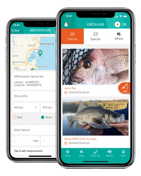
For recreational fishers, the platform delivers location specific fishing information through mobile applications for iOS and Android devices. Users opening the application see their current location on an interactive map with fishing zone boundaries clearly displayed and colour coded based on regulatory status. Selecting a zone displays applicable regulations including permitted species, bag limits, size restrictions and gear rules specific to that location. Offline functionality ensures fishers can access this critical compliance information in remote areas without mobile coverage, with the application pre loading geospatial data and regulations for their region. Optional catch logging allows users to record their fishing activity with photos, species identification and location data, maintaining private records or choosing to share data with DPIRD Fisheries for research purposes.
Impact
For NSW–DPIRD Fisheries, the platform has fundamentally improved their capability to maintain accurate fishing zone geospatial data and rapidly update or correct fishing regulations across NSW waters. The Mapbox Studio integration enables fisheries mapping specialists to refine zone boundaries with approximately one metre precision, ensuring legislated areas are accurately represented and eliminating ambiguity about where specific regulations apply. When regulations change due to new legislation, seasonal closures or environmental conditions, authorised staff update the single source of truth in Mapbox with changes becoming available to over 350,000 platform users immediately through API synchronisation, eliminating the delays and inconsistencies of traditional printed guide distribution.

The platform has reduced administrative burden on NSW DPIRD Fisheries through automated information distribution, replacing manual processes for updating printed materials and responding to individual information requests. Push notification capabilities enable targeted communication with specific user groups about regulatory changes, safety warnings or fisheries management initiatives. Optional catch log data voluntarily shared by users provides valuable fisheries research information previously difficult to collect at scale, supporting evidence based management decisions. The platform’s audit logging and content management capabilities ensure regulatory information updates are traceable and accountable, supporting governance requirements.
For recreational fishers, the platform delivers reliable, location specific fishing regulations exactly where and when needed. Users accessing the application see fishing zone boundaries precisely matching legislated areas with associated regulations including rules, bag limits, size restrictions and permitted gear displayed for their current location. This accuracy eliminates guesswork and significantly reduces unintentional compliance issues caused by outdated information or misunderstanding zone boundaries. The offline functionality ensures critical compliance information remains accessible in remote fishing locations without mobile coverage. Since launching in 2015, the platform has achieved over 350,000 mobile application downloads, representing significant adoption across the recreational fishing community and demonstrating its value as the trusted authoritative source for NSW fishing information.
Try it for yourself!
The FishSmart app provides you with the essential information you need to fish recreationally in NSW. Powered by Mobiconnect.