InvoCare operates over 300 funeral locations, 17 cemeteries and 29 crematoria, competing in markets across Australia, New Zealand and Singapore.
InvoCare Group
Overview

An Innovative Approach and Commitment to Diverse Community Needs
InvoCare, headquartered in Sydney, is a leading provider of funeral services in Australia, New Zealand, and Singapore. It also operates private memorial parks and crematoria in Australia and New Zealand.
InvoCare is continually seeking to innovate by adopting new approaches, exploring new opportunities and utilising new technologies to assist client families in farewelling their loved ones.
In line with its commitment to Innovation, Vocation and Care, InvoCare’ cemeteries and crematoria are responsive to the changing needs of the communities they serve. This adaptability is evident in the introduction of new developments and memorial sections tailored to the needs of specific cultural or religious groups. Notable examples include Asian sections designed with the advice of Feng Shui advisors and elaborate crypts, vaults and family mausoleums favoured by many European communities.
Problem Statement
Challenges with the inconsistency of maps across venues
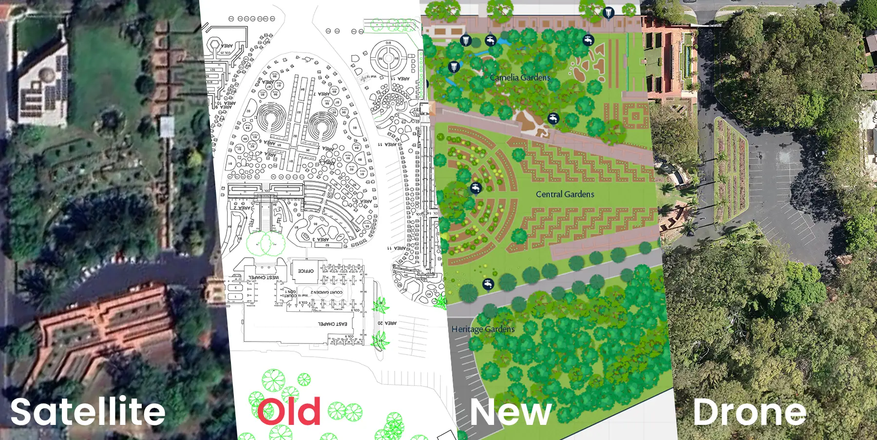
InvoCare’s memorial parks and cemeteries are subject to constant development, with regular introductions of new sections and ongoing development work. The rapid pace of these changes renders traditional map suppliers and satellite imagery, often outdated by five years or more, insufficient for accurate navigation within these venues.
InvoCare is dedicated to supporting clients, their families, and friends at critical times in their lives. This commitment involves not only compassion, exceeding expectations, and delivering outstanding service but also providing clear and comprehensive maps to facilitate straightforward navigation across all their sites.
Currently, InvoCare faces a challenge with the inconsistency of maps across its venues, compounded by a lack of uniform digital versions of these venue maps.
Looking to the future, InvoCare has discussed incorporating wayfinding capabilities powered by Mobiconnect. This enhancement aims to provide driving and walking directions to any specific memorial location. To achieve this, new maps must be created with this future functionality in mind. These maps require accurate scaling and geographical alignment to ensure that the latitude and longitude data from phone GPS systems are precisely represented, thus enabling efficient and reliable navigation for visitors.
Our Thinking
Using Drones and Aerial Photography for Accurate and Accessible Memorial Park Maps
The team at Mobiddiction conducted a thorough review of the available satellite imagery for each memorial park in NSW and QLD. They found that this imagery was not sufficient to create accurate and up-to-date maps for most of the venues. The absence of a consistent source of on-ground surveys, construction drawings, or section plans further complicated the process. Additionally, the size of the sites made regular on-ground surveying an impractical and costly method for gathering updated data.
Considering the specific locations and any airspace restrictions, the team identified drone overflights and aerial photography as a viable option. This approach would enable the rapid generation of hundreds of overlapping, high-resolution images that are accurately geolocated. These images could then be post-processed into a single, comprehensive image for each venue.
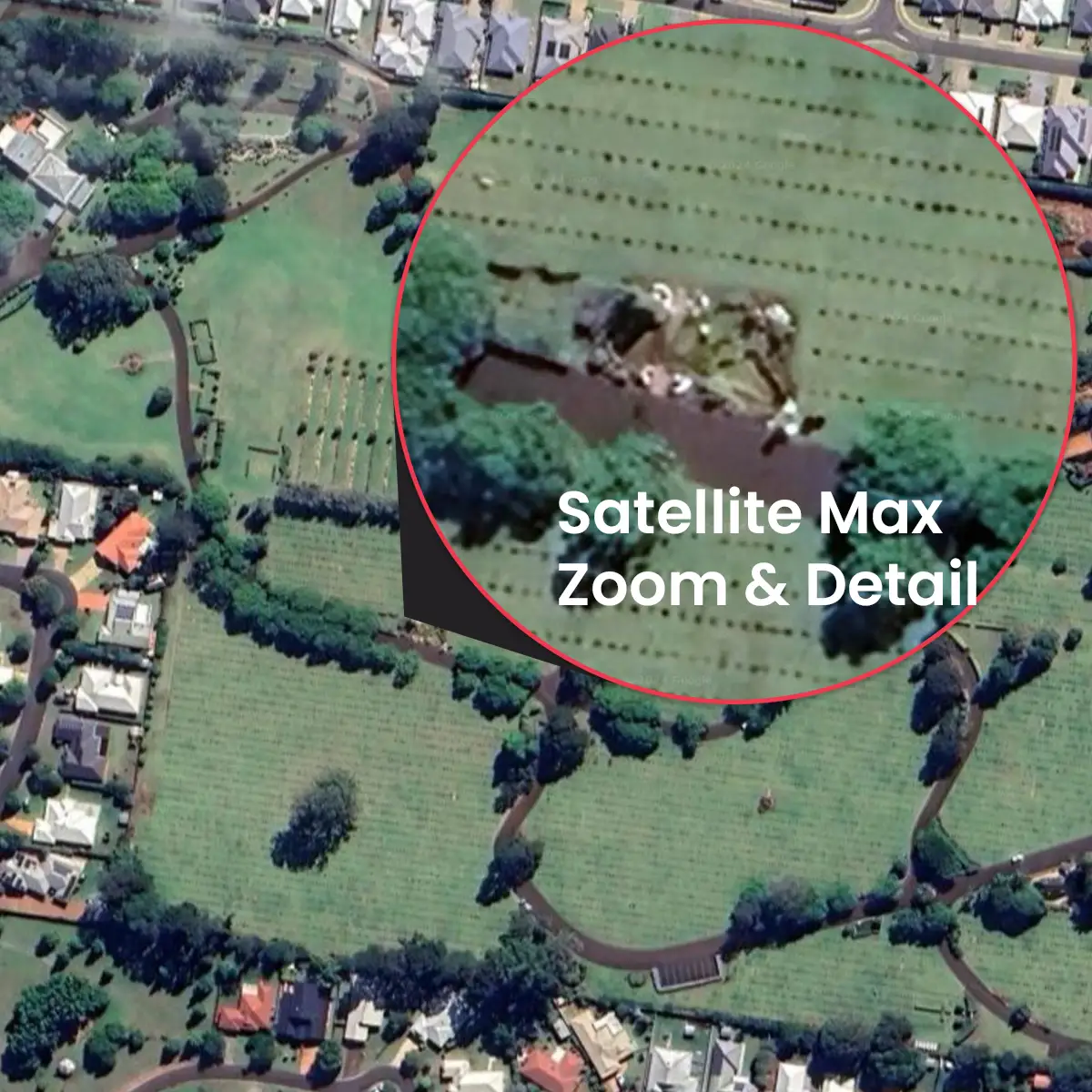
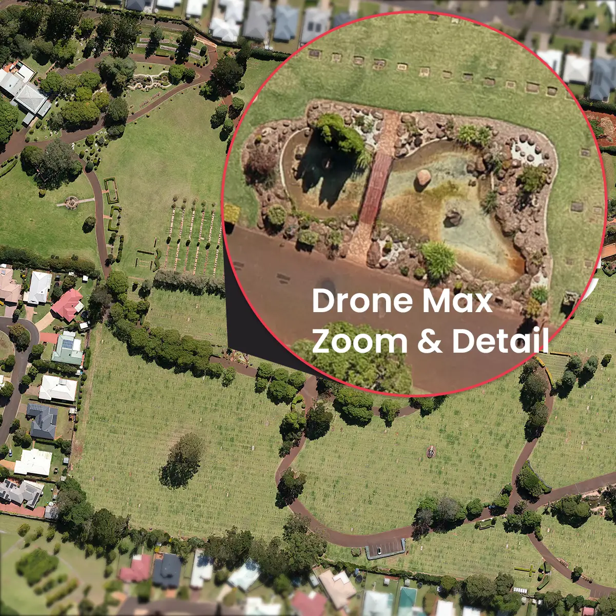
The resulting imagery would serve a dual purpose. Firstly, it could be used to create “satellite view” map tiles, which could then be overlaid on existing platforms like Google and Apple maps for dynamic mapping on websites and mobile apps. Secondly, it would provide an accurate foundation for the creation of custom illustrated maps, designed in a consistent corporate style.
Furthermore, the team chose to supplement this with regular and 360-degree photography to capture essential details and add to the reference material used by map illustrators. This approach is particularly crucial for documenting specific features and requirements not clearly visible in top-down aerial photographs, such as stairs and curbs. These details are vital for creating maps that are accessible and useful for disabled way-finding.
Design
Crafting Consistency in the Map Design for each Venue
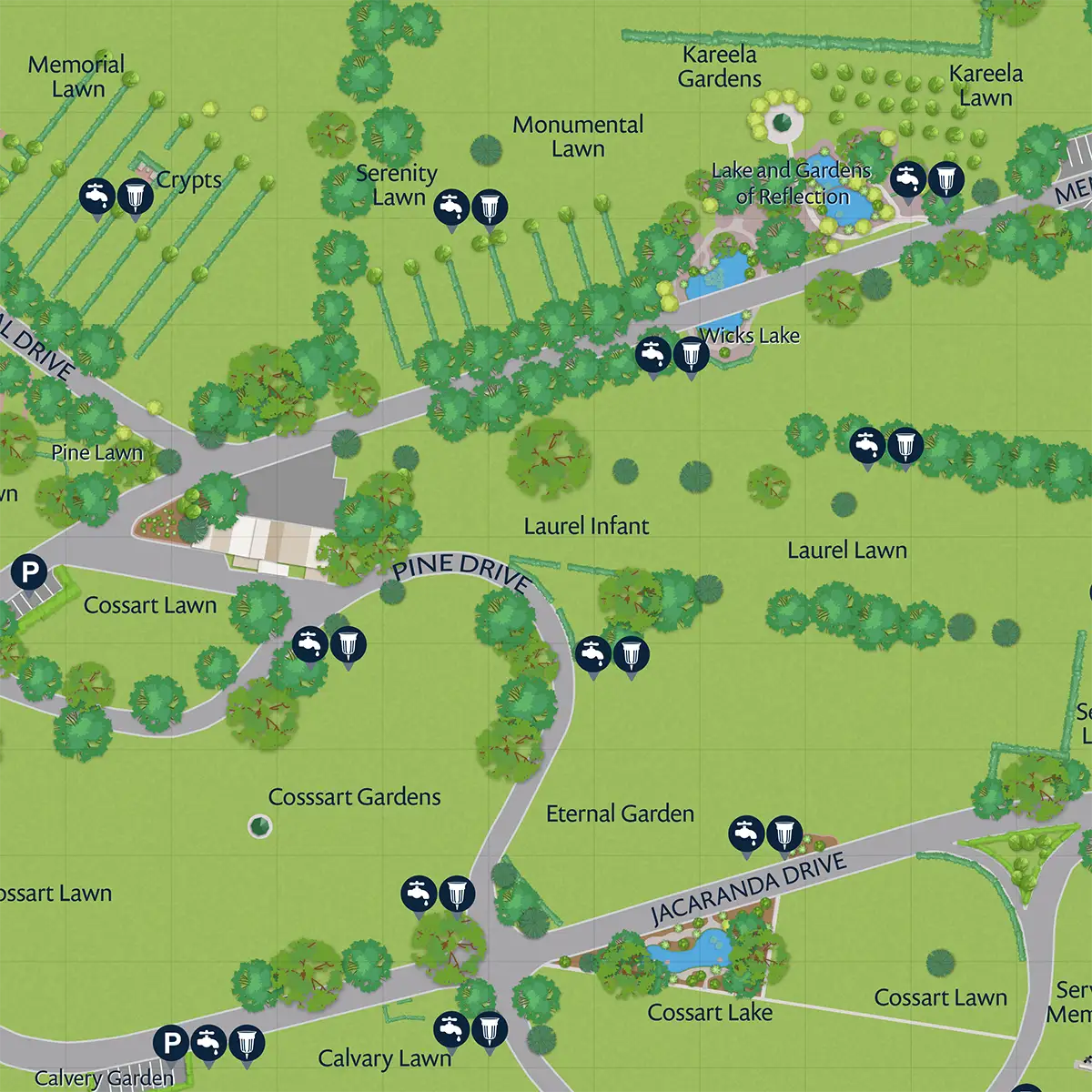
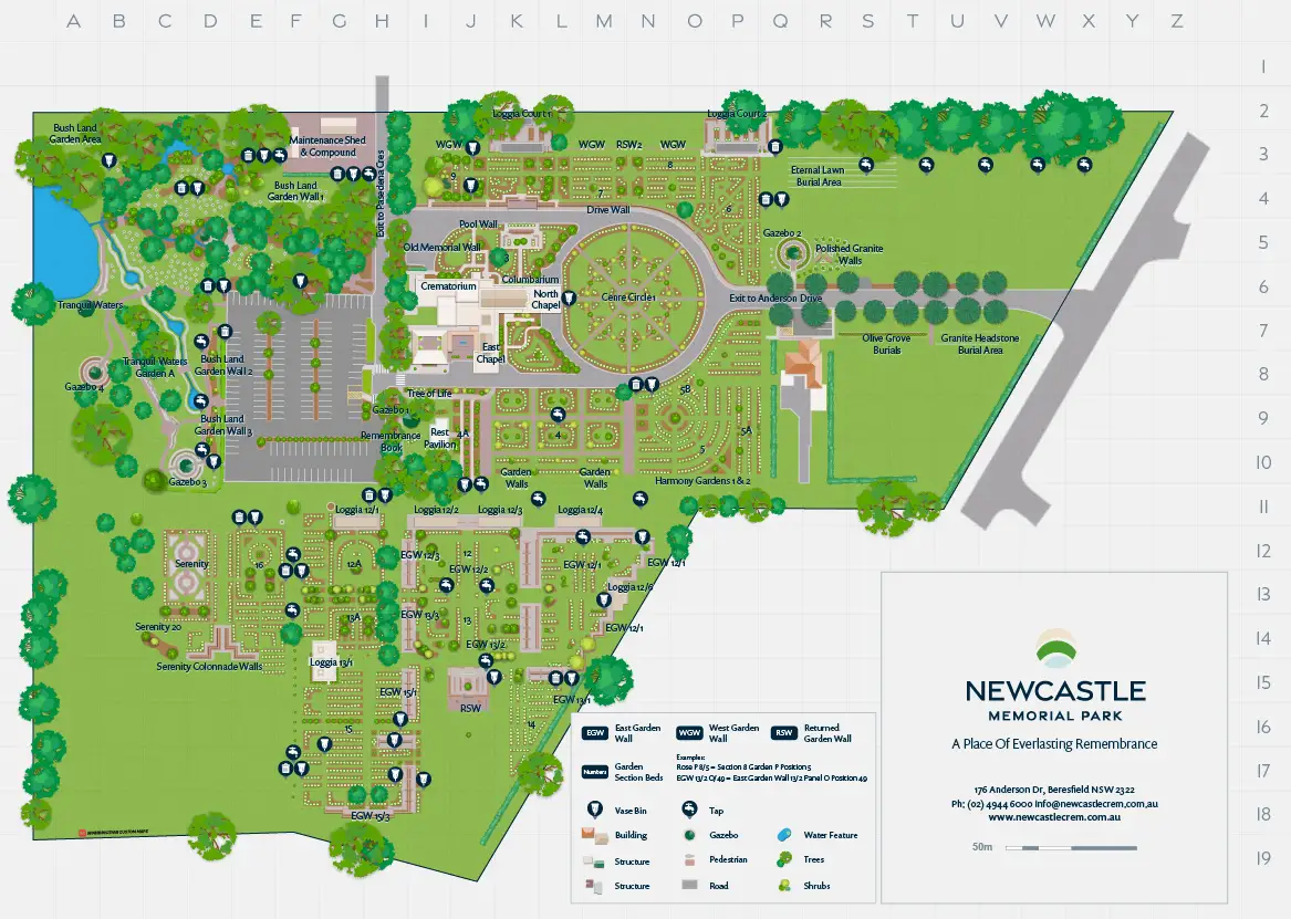
Our specialist mapping design team at Mobiddiction worked with InvoCare Group’s marketing and comms team to define with a map style guide that complied with the relevant parts of the corporate style guide.
This style guide included consistent design elements for roads, buildings, trees, lakes/ponds, signage, and POI (Point Of Interest) icons. There is also a design language with consistent and reusable elements for the various industry specific map requirements and features such as the various memorial options, crypts, and vaults, and religious or culturally specific sections like their Lung Po Shan Chinese Memorial Garden.
Most of the venues had a map of some kind, usually a printed paper map handed out at reception. Consistency with existing maps was taken into consideration, for where staff and visitors were familiar with those maps. There would typically be a transition period between ongoing use of stocks of paper maps and rollout of the new maps.
These elements were all created as vector graphics, allowing display at any size or zoom level without loss of image resolution.
Each venue map needs to be created in a “north up” orientation, as well as matching any pre-existing map orientation (usually where the shape and layout of a venue is historically or more logically oriented in a non-north-up orientation). This means things like icons and text labels need to be created in layers to allow rotation of the underlying map while retaining text and icons in readable orientations.
Development
We scheduled site visits and sent the drone and photography teams to each venue to collect all the required imagery. As well as drone aerial photography we collect regular photographs and 360-degree photography were suitable, for reference and better on ground understanding for the design team.
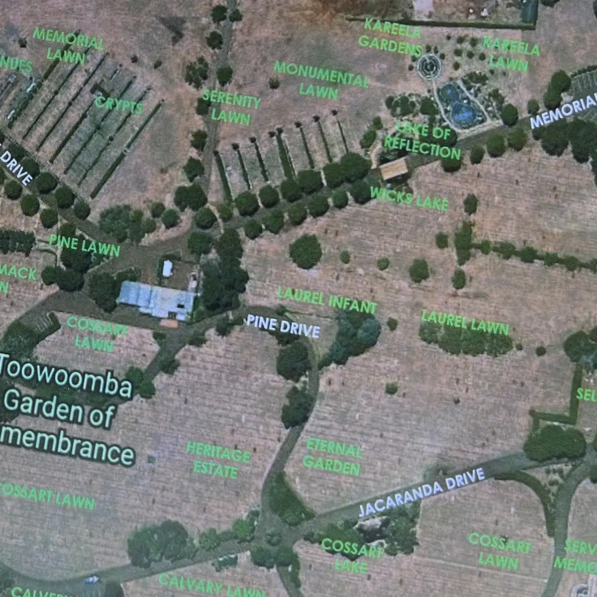
The aerial photography was post processed using a combination of photogrammetry, image stitching, and geo location data collected with each image. This resulted in a single image for each venue that is very high resolution, often 30,000 or more pixels across. The photogrammetry also creates an elevation map, allowing the designers to “see” elevation changes and slope gradients that are non-obvious in the aerial photographs.


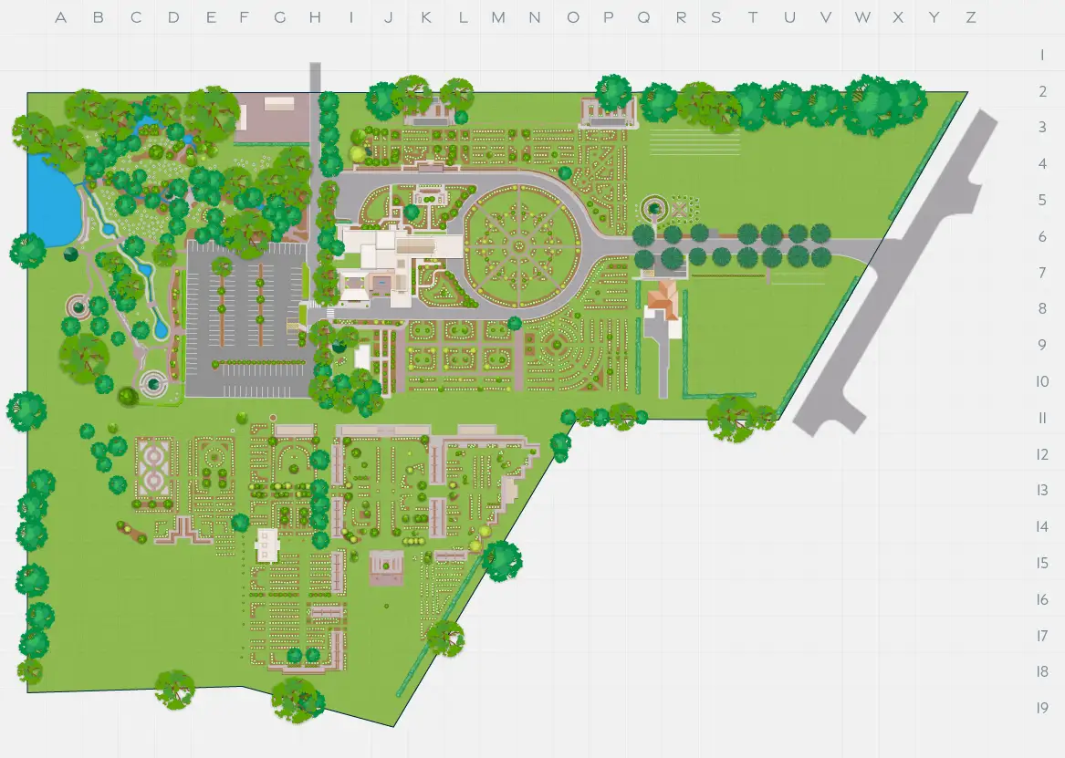
These high-resolution images were used to create vector illustrations of the venues – incorporating the style guide and design language elements to ensure consistency and compliance with agreed and corporate styles.
The vector illustrations were created in layers, allowing the same base file to have different layers turned on or off, for example to create different sized labels, icons, and street names – so that the map stays consistent with label text size as you zoom in and out.
The vector files were then exported into all required output formats, PDFs for downloads and printing, jpegs or png’s for embedding on web pages. An example of this was the base map was used for an open at the Northern Suburbs Memorial Park open in a flyer for use on the day for visitors at the venue.
”It's been a pleasure working with the team, and this collaboration has evolved into a true partnership. Our joint efforts are centered on enhancing the client experience for the families we serve. A key aspect of this improvement is easing the navigation of our grounds, making it simpler and more intuitive for visitors to locate their loved ones' resting places. This partnership underscores our commitment to providing compassionate and efficient services, reflecting our dedication to the families and communities we serve.
Lauren CummingsHead of CX & Marketing - Pet and Cemeteries & Crematoria.
Ongoing
Streamlined Process for Venue Updates and User-Friendly Custom Maps
All the source maps are in layered vector files, so additions or changes to the map as new development work at venues occurs are simple.
Small or well-defined changes are mostly able to be done from plans, descriptions, and photographs. For larger changes we can use localised drone missions without needing to overfly the entire venue again, thanks to the geo data saved with each aerial photograph taken.
”We have built these custom maps for Invocare NSW & QLD keeping in mind the overall user experience and to bring in consistency and more so ensuring that the maps are meaningful, and visitors get to their locations with ease, especially considering the venues, and how important it is to provide this utility really quickly
Mike VasavadaDirector – Mobiddiction
The geo reference maps showing up to date on-ground memorials will allow the creation of a tool to create and maintain a database of memorial site locations.
Truly, one of it’s kind and a first of it’s kind. We thank the team at InvoCare for having given us this opportunity.