call 1300 600 670 contact_support Contact Us

Fisheries and
Compliance

FishSmart platform Australia

Digital tools that support safer waterways, clear regulatory communication, and long term environmental stewardship.

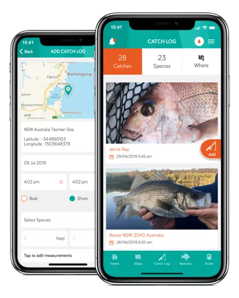
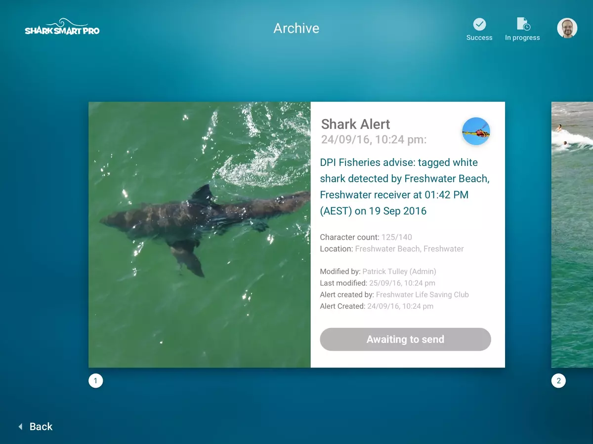
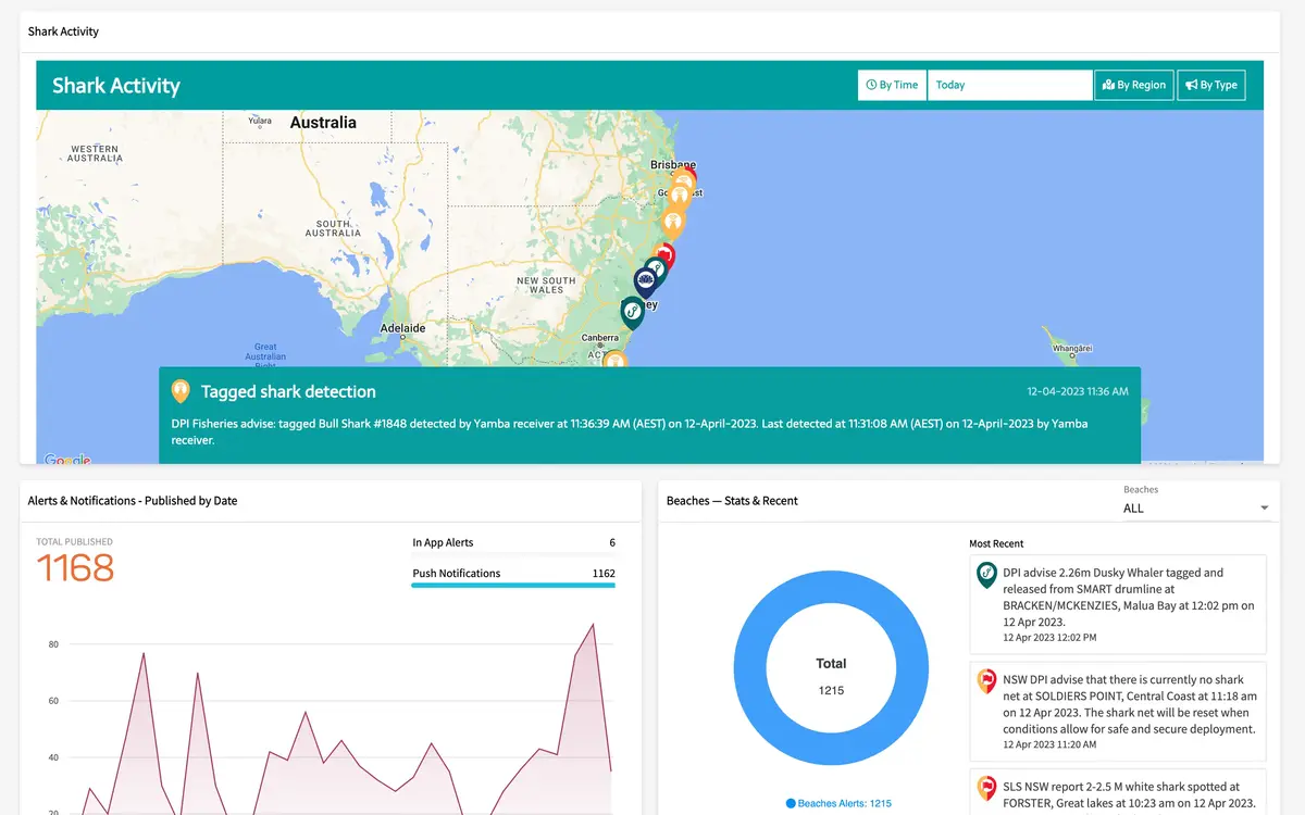
Mobiddiction has worked in the fisheries, conservation and marine compliance space for more than a decade. Our platforms help agencies communicate rules clearly, visualise complex spatial boundaries, collect field and crowd sourced data, and operate real time public safety systems. These programs sit at the intersection of environmental protection, community safety and compliance, and our long term partnerships reflect our reliability in high trust government settings.

Our experience spans coastal safety programs, marine park and fisheries regulation, wildlife tracking, and public engagement tools. Each program has required secure architecture, accurate geospatial modelling, resilient public systems and operational tools for departmental staff.

Wild About Whales

WhaleWatch

Originally launched in 2012 for the NSW National Parks and Wildlife Service as Wild About Whales, this was one of the first large scale crowd sourced wildlife observation platforms in Australia. For nearly a decade it supported the annual whale census and provided a dependable public reporting tool for sightings along the NSW coastline, and provided near real time information useful for planning whale watching trips.

After NPWS funding priorities changed in 2022, Mobiddiction with permission from NPWS relaunched the program independently under a different program name as WhaleWatch, continuing to provide the community with a live and historical view of whale movements. We then built additional features on the platform with non-mandatory registrations with real time public sightings gallery and real time notifications, WhaleWatch program has garnered widespread support from the Whale enthusiasts, tour operators conservation organisations and some content producers.

The platform standardises sightings data, validates submissions and offers intuitive map and location based visualisation for planning whale watching trips and coastal expeditions. It remains one of our most enduring conservation focused digital services and demonstrates the value of well structured data models, clear UX and stable public infrastructure powered by Mobiconnect components.

Whales About Us
FishSmart Updates Phone
DPIRD NSW

FishSmart

FishSmart NSW is a popular platform and program delivered for NSW DPIRD Fisheries, acting as a primary digital companion for recreational and commercial fishers across the state. Its core purpose is clarity and to provide the right rules, in the right location, at the right time.

FishSmart integrates directly with the department’s GIS and Mapbox environment, which serves as the single source of truth for all spatial data and regulatory boundaries. This includes marine park zones, restricted areas, seasonal closures, Fish Aggregating Devices, and artificial reefs. The FishSmart mobile app displays these boundaries and locations with high spatial accuracy, including coverage of Lord Howe Island.

Mobiconnect™ functions as the content platform layer for non spatial content such as species information, equipment guidelines, identifiers, bag limits and gear rules, notifications, catch logs and explanatory material. All of this is delivered through a clean interface designed for quick reference on the water or in the field.

The program has been in continuous development since 2015, and supported by Mobiddiction’s managed services, cloud hosting and structured release cycles with ongoing reporting and feature development.

DPRID NSW

SharkSmart and SharkSmart PRO

The SharkSmart Program, operated by NSW DPIRD, is one of the state’s most visible public safety systems. Mobiddiction has supported the platform since 2014, delivering architecture, development, operations and ongoing improvement. It combines real time data feeds from tagged shark detections, environmental sensors, aerial surveillance and departmental systems into a unified coastal safety platform.

The public map offers live shark activity, beach safety information and guidance for coastal users.

SharkSmart PRO, used internally by authorised government staff, contractors, and beach safety organisations, provides operational tools for incident assessment, communication and situational awareness.

sharksmart pro maps

Both systems rely on Mobiconnect, geospatial data modelling, real time API integrations and a secure multi environment cloud architecture hosted on AWS. They demonstrate how well designed digital platforms support compliance, risk reduction and public trust across long running marine programs.

SharkSmart Pro
sharksmart

Why Agencies Choose Mobiddiction

Deep Understanding of

Fisheries and Coastal Regulation

A track record spanning more than a decade across marine parks, wildlife, fisheries, coastal safety and environmental compliance programs.

Proven

Geospatial Expertise

Experience working with Mapbox, ESRI/ArcGIS, departmental GIS platforms, and precise marine zoning and boundary logic.

ESRI

Mapbox spatial specialist australia

map embed example copy
sharksmart apps delivery team mobiddiction
Stable

Long Term Partnerships

Many programs have run for 8 to 12 years, reflecting our strength in maintenance, iteration and operational readiness.

Secure,

Trusted Digital Foundations

All programs are delivered within our ISO27001 certified security framework and hosted on secure Australian cloud environments.

Mobiddiction is an ISO Certified Technology Company Australia
FishSmart - 6
Clear Communication of

Complex Rules

Interfaces and information models designed to support regulatory clarity for both public and departmental users.

Strong

Operational Capability

Reliable managed services, incident response, seasonal uplift for high risk periods, and structured support for ongoing departmental operations.

Newcastle Map 3

Clear Rules, Real-time Data, and Trusted Marine Compliance Systems.

Your local experts

    Close Menu