call 1300 600 670 contact_support Contact Us

Strategic
Government Programs

Features
Operational Stability
Strategic ICT Consultancy

Long Term Program Delivery and Trusted Managed Services

Mobiddiction builds field mobility tools that support staff working in remote, distributed or regulated environments. These tools combine real time positioning, offline capability, spatial overlays and tight integration with enterprise systems.

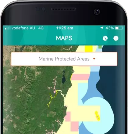
For Forestry Corporation of NSW, we support a field platform that integrates ESRI ArcGIS services and high precision RTK GNSS receivers. Operators use it to view boundaries, zones and planning layers while working in the field. The app includes a dynamic boundary warning system that alerts operators as they approach harvesting limits, helping maintain compliance with EPA requirements. It can sync in connected areas and then continue to operate offline with accurate boundaries and maps.

FCNSW - Map App - 3
NSW Survey Marks for NSW Spatial Services

Foundational Geospatial Infrastructure with Long Term Operational Stewardship

We provide strategic IT consulting, architectural support, and spatial data guidance for the NSW Survey Marks platform used by surveyors, planners and engineers. Our role has included reviewing spatial data workflows, ensuring stable ESRI integration, assessing information architecture, and delivering enhancements that support state wide land management. This program demonstrates our ability to maintain system integrity over many years while providing advisory input that shapes future capability.

survey mark featuers
sharksmart apps delivery team mobiddiction
SharkSmart for NSW DPIRD Fisheries

A Statewide Public Safety Program Supported by Strategic Digital Oversight

SharkSmart requires careful planning, structured governance and clear alignment with departmental and whole of government priorities. Mobiddiction leads architectural assessment, data integration planning, system design and ongoing service management. The platform ingests real time environmental data and presents information to both the public and internal operational teams. Our role includes strategic guidance, development, cloud operations, continuous improvement and managed services.

fishsmart insights
FishSmart for NSW DPIRD Fisheries

Spatial Regulation and Legislative Content Supported by Clear Technical Strategy

Mobiddiction provides analysis and recommendations on mapping, geospatial integration, content architecture and future enhancements. We assess regulatory data flows, integration with MapBox Studio and usability expectations for both recreational fishers and agency staff. We deliver all technical development, hosting and operational support within a structured service framework.

map app
FCNSW - Map App - 1
MapApp for Forestry Corporation of NSW

Operational Field Mapping with Strong Strategic and Spatial Design Capability

MapApp depends on accurate GIS data, real time GNSS inputs and safe operational workflows. Mobiddiction provides architectural planning, boundary risk evaluation, spatial modelling, and strategic advice on mobile field operations. We support offline capability, high accuracy RTK receivers, GNSS boundary warnings and continuous updates within a disciplined support and maintenance model.

Wild About Whales for NSW National Parks and Wildlife Service

Early Spatial Innovation Informing Later Statewide Programs

Beginning in 2013, Mobiddiction delivered mapping, sightings data, mobile updates and public information for coastal wildlife programs. This early work established the foundations of our long term spatial capability and our approach to strategic planning for public facing services.

iphone background whales 1
FarmGate Images 3
Drought and Supplementary Feed Calculator for NSW DPIRD Agriculture

Technical Design and Advisory Support for an Important Decision Support Tool

Mobiddiction assessed data requirements, workflow behaviours and regional complexity to recommend a solution structure that supports producers during drought conditions. The platform reflects our ability to combine advisory work with reliable development and managed services.

Expertise in Emerging Technologies

Mobiddiction brings practical experience in emerging technology that strengthens government programs. Our drone operations and aerial capture workflows support precise mapping for Invocare, Forestry and HomeWorld. These capabilities provide cost effective and up to date spatial layers for planning, operations and community engagement.

We also apply AI tools that enhance development, operations and service quality. Our engineering teams use intelligent automation for code reviews, regression checks and documentation. Operations teams use AI supported analysis to triage incidents, monitor usage patterns and assess system performance. For spatial and data heavy programs, we use AI to extract insights, validate geospatial layers and support visualisation. Our cyber defence work includes AI assisted log analysis, anomaly identification and event correlation. We also use AI to generate draft content for customer support material and knowledge bases, which is then reviewed by experienced staff.

AR VR AI Virtual Reality Agency Mobiddiction
PatientVR and Investment NSW Team

Why Government Agencies Engage Mobiddiction

Strategic IT Consulting at Program Scale

We provide architectural reviews, technology assessments, roadmaps and program analysis that guide multi year government initiatives.

Long Term Trusted Delivery

Many of our programs have operated with us for eight to twelve years, reflecting consistent quality and stable managed services.

Secure and Compliant Operations

Mobiddiction is ISO27001 certified, giving agencies confidence that governance, security and documentation requirements are properly managed.

Breadth of Capability under a Single Operating Model

We combine engineers, spatial specialists, cyber security practitioners, DevOps teams and project managers working together with clear accountability.

Cost Effective Delivery Supported by Mobiconnect

Our platform accelerates development, simplifies updates and ensures consistent performance for government scale workloads.

Future Ready Design and Modernisation Support

Our spatial, AI, cloud and mobile capability helps agencies modernise systems safely and efficiently.

Long Term Strategic Government Programs.

Send us a Message

    Close Menu